
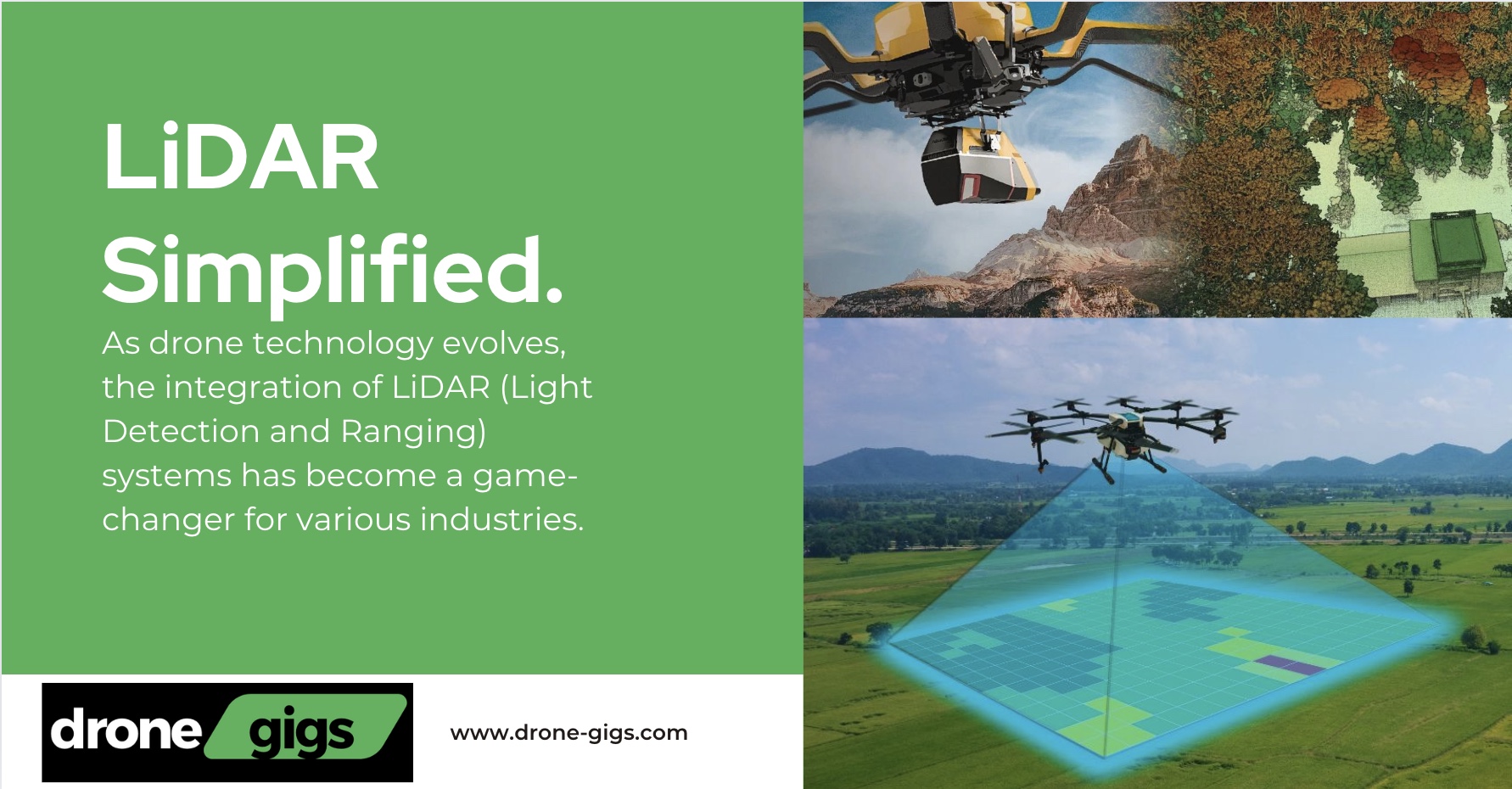
As drone technology evolves, the integration of LiDAR (Light Detection and Ranging) systems has become a game-changer for various industries. LiDAR drones are now essential tools for highly accurate mapping and 3D data collection, offering solutions for surveying, agriculture, forestry, and more. By using laser pulses to measure distances, LiDAR drones create detailed point clouds, providing critical insights into landscapes, infrastructure, and natural environments.
Table of Contents
What Is LiDAR and How Does It Work?
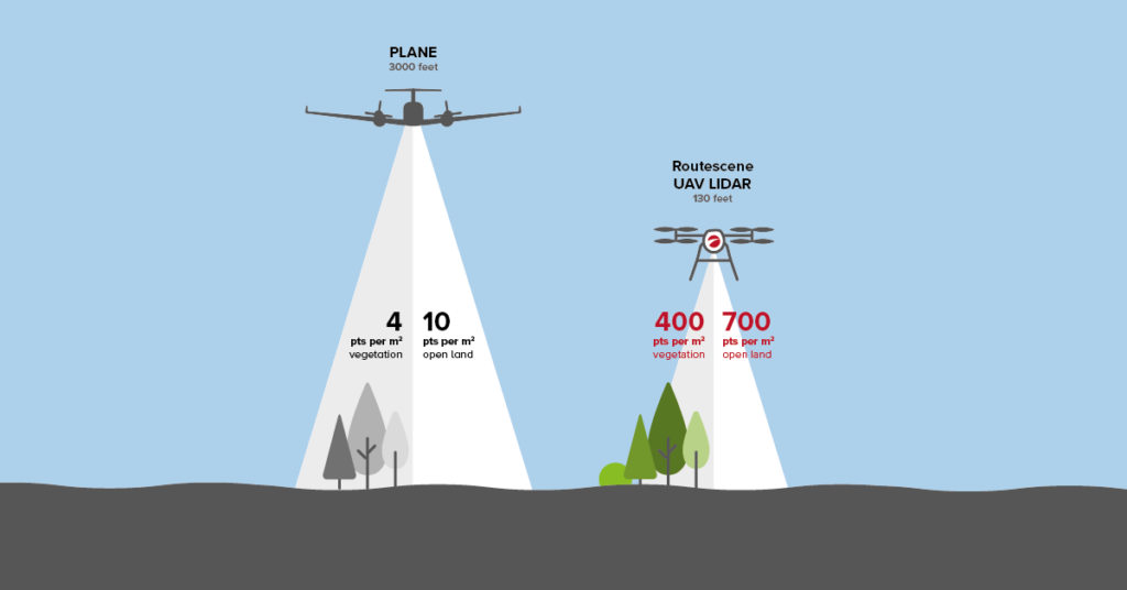
LiDAR uses laser pulses to measure distances by timing the return of each pulse to the sensor after it bounces off an object or the ground. Mounted on drones, this technology captures 3D data that is often called a point cloud, which creates a highly detailed map of the scanned area. What makes LiDAR drones exceptional is their ability to collect data in a wide range of conditions, including low light and dense vegetation, making them ideal for hard-to-reach or complex environments.
Unlike traditional photogrammetry, which relies on images and requires ideal lighting conditions, LiDAR can function regardless of time of day or weather, offering a more versatile and reliable data collection tool.
Key Benefits of LiDAR Drones
- Incredible Precision: LiDAR drones offer centimeter-level accuracy, which is crucial for applications like topographical surveys, construction site mapping, and infrastructure inspections. By using precise laser measurements, you can create extremely detailed terrain models.
- Faster Data Collection: LiDAR-equipped drones can cover large areas much more quickly than traditional ground surveying methods. In a single flight, a LiDAR drone can collect data for a wide area, drastically reducing the time spent on mapping projects.
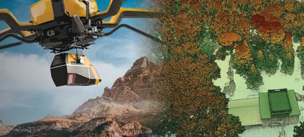
- Penetration of Dense Vegetation: LiDAR’s ability to penetrate through canopies and dense foliage makes it perfect for industries like forestry, agriculture, and archaeology. The laser pulses can reach the ground beneath trees or brush, providing data that would be difficult to capture with standard cameras or other sensors.
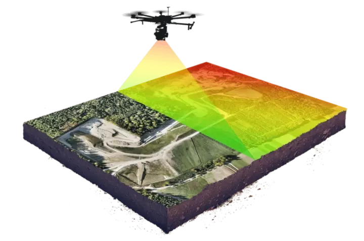
- 3D Mapping Capabilities: LiDAR drones produce 3D point clouds that provide a full view of the terrain, including elevation changes, structures, and natural features. This is especially useful for geological studies, road design, and flood risk assessments, where terrain features must be accurately captured.
- Adaptability to Environmental Conditions: Since LiDAR doesn’t rely on sunlight, it can be used in low-light environments or poor weather conditions, such as fog. This makes it far more versatile than traditional imaging technologies that need clear skies and strong lighting.
Popular LiDAR Drones and LiDAR Sensors
Here are a few popular LiDAR products available for drones, which highlight the variety of options for different industries and use cases:
- DJI Zenmuse L1: This is one of the most advanced LiDAR payloads from DJI. The Zenmuse L1 integrates a Livox LiDAR module, a high-precision IMU, and a camera with a 1-inch CMOS sensor. This product is ideal for surveying, mapping, and forestry management, offering highly accurate 3D data and real-time point cloud models.
- Yellowscan Mapper: The Yellowscan Mapper is a compact and lightweight LiDAR system designed specifically for UAV applications. It is easy to integrate with various drone platforms and is suitable for industries like agriculture, forestry, and civil engineering. With its combination of accuracy, compact size, and versatility, the Yellowscan Mapper is popular for precision mapping.
- RIEGL miniVUX-1UAV: Known for its compact design and high accuracy, the miniVUX-1UAV is a popular LiDAR scanner for drone-based mapping. It is particularly effective in forestry and environmental monitoring, offering detailed vegetation analysis and the ability to create accurate topographic models even in challenging environments.
- Velodyne Puck: The Velodyne Puck is a popular LiDAR sensor used in many autonomous vehicles and drone applications. It provides a 360-degree field of view and is commonly used for urban mapping, infrastructure inspection, and autonomous navigation. Its lightweight design makes it a good fit for drone integration, especially when capturing large outdoor areas.
- LiAir V: The LiAir V from GreenValley International is a compact, lightweight LiDAR sensor specifically designed for drone-based mapping. This sensor is particularly useful for applications like mining surveys, construction planning, and forest resource management, thanks to its high-density data output and ability to penetrate vegetation.
Key Applications of LiDAR Drones
LiDAR drones have a wide range of applications across many industries. Some of the most impactful include:
- Surveying and Mapping: LiDAR drones have become essential tools for surveyors, particularly in topography. These drones can generate digital elevation models (DEMs) and digital terrain models (DTMs) that are used for land development, infrastructure design, and environmental studies.
- Forestry Management: In forestry, LiDAR drones provide a detailed view of tree height, canopy structure, and ground features. These insights help forest managers monitor forest health, track carbon sequestration, and plan sustainable resource use.
- Archaeology: LiDAR technology has uncovered lost ancient cities and hidden structures under dense vegetation. For example, drones equipped with LiDAR have been used to discover hidden Mayan ruins in the Yucatan Peninsula, offering insights into historical landscapes that would otherwise be difficult to explore.
- Agriculture: LiDAR drones help farmers in precision agriculture by generating maps of their fields, identifying areas that need better irrigation, erosion control, or improved soil health. Farmers can use these insights to optimize crop yields and reduce resource waste.
- Disaster Response and Environmental Monitoring: LiDAR drones are increasingly used in disaster management to create flood models, assess landslide risk, or monitor wildfire zones. After natural disasters, LiDAR drones provide rapid assessments that can help emergency response teams focus their efforts in the most critical areas.
Challenges of LiDAR Drones
Despite their numerous advantages, LiDAR drones also face several challenges:
- High Costs: LiDAR sensors and the drones capable of carrying them are often expensive, making them a significant investment, especially for smaller businesses. However, as technology advances, prices are expected to decrease, allowing wider adoption.
- Data Processing: The sheer volume of data produced by LiDAR sensors requires significant processing power. Turning the raw point clouds into usable maps or models involves specialized software, which can be expensive and complex to use.
- Limited Flight Time: Since LiDAR sensors consume a lot of power, drone flight times are often limited, which can be an issue when mapping large areas. Advances in battery technology and sensor efficiency are expected to improve this in the future.
The Future of LiDAR Drones
The future of LiDAR drone technology is bright, with several trends expected to shape its development:
- Decreasing Costs: As LiDAR components become cheaper, more industries will be able to integrate the technology into their operations, making LiDAR drones more accessible to businesses of all sizes.
- Real-Time Processing: Advances in on-board computing will soon allow for real-time LiDAR data processing, enabling immediate access to 3D maps without the need for lengthy post-processing.
- Improved Battery Life: Continued innovation in battery technology will lead to longer flight times, allowing LiDAR drones to cover larger areas in a single mission.

Conclusion
LiDAR drones are transforming the way industries gather and analyze geospatial data. From creating detailed 3D maps for construction projects to uncovering hidden archaeological sites, the use of LiDAR technology is proving to be a valuable asset across multiple fields. While the current costs and data processing challenges may pose barriers to entry, the future of LiDAR drones promises greater affordability, improved efficiency, and a wider range of applications. As the technology continues to advance, LiDAR drones are set to become a standard tool in fields where accuracy and precision are paramount.
By incorporating LiDAR into drones, professionals across industries can enhance their data collection, streamline workflows, and unlock new insights, paving the way for smarter decision-making in the future.
Best Drones for Fishing in 2024Why the DJI Neo Could Be the Best Budget Drone of 2024Why Chinese Drones Are DominatingDJI Neo LeakDJI Air 3S LeakTop Drone Camera of 2024Drone Weight Carrying CapabilitiesGuide to Drones that Follow YouHow Far Can Drones Fly?Top 5 Beginner Drones of 2024The Ultimate Guide to Racing DronesIs DroneDeploy the Ultimate Solution?DJI Mini 4 Pro ReviewDrone Security for BusinessEnvironmental Drone MonitoringDrone Assist: Your Key to Seamless FlyingDJI Avata 2: In-Depth ReviewSearch and Rescue DronesDrone Inspection Business GuideTop Drone Business Ideas in 2024Autel Alpha UnveiledAgriculture Drone Business in 2024Starting a Drone Photography BusinessFlying Beginner Drones in 2024DJI Mavic 3 ReviewDrone License Requirements WorldwideThe Ultimate Guide to DJI DronesBest Drone Video Editing SoftwareHoly Stone Drones: Features and PerformanceMini Drones GuideParrot Drone OverviewDJI Mini 2 vs Mini 2 SEDrone Insurance Options for 2024
Pingback: Comparing LiDAR Drones for Sale: Capabilities and Best Options - Drone Gigs
Pingback: The Shocking Truth: How One Drone Accident Almost Shut Down a Major UK Airport — Are We on the Verge of a Catastrophe? - Drone Gigs